![Peta Rawan Bencana SULTRA PDF [PDF]](https://pdfs.asia/img/200x200/peta-rawan-bencana-sultra-pdf.jpg)
7 0 656 KB
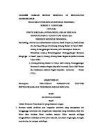
27
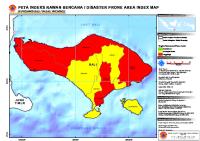
PETA INDEKS RAWAN BENCANA / DISASTER PRONE AREA INDEX MAP DI PROVINSI SULAWESI TENGGARA / IN SOUTH EAST SULAWESI PROVINCE Keterangan lokasi / Location diagram SULAWESI SEL ATAN 3°0'0"S
SULAWESI TENGAH
Legenda Legend/ Legend Batas Propinsi / Province Boundary
KONAWE
Batas Kabupaten / District Boundary
SULAWESI T ENGGARA
Tingkat Kerawanan/Prone Level
KOLAKA UTARA
Rendah/Low Sedang/Moderate Tinggi/High Tidak Ada Data/No Data
KOLAKA
4°0'0"S
Informasi Kartografi / Cartographic Information
Å
KOTA KENDARI
KONAWE SELATAN
L
A
U
T
B
A
N
D
A
0
15
30
60 Kilometers
Skala / Scale : 1 : 1.500.000 pada ukuran A3 / 1 : 1.500.000 at A3 size 1 cm di peta sama dengan 15 km dilapangan / 1 cm equals with 15 km in the field Proyeksi Lokal / Local Projection : UTM, Zone 51 South Proyeksi Geografi / Geographic projection : Lintang - Bujur / Latitude - Longitude
MUNA BOMBANA
Datum Unit : WGS - 84
5°0'0"S
Unit Grid / Grid Unit : Lintang - Bujur dengan interval antar grid 1 derajat / Lat - Long with interval 1 degree
Sumber Data / Data Source Gambar background / Image background : Blue Marble Batas administrasi/administrative boundary : Peta digital Bakosurtanal/ Bakosurtanal digital map Skala 1 : 250.000 / Scale 1 : 250.000
WAKATOBI
BUTON
KOTA BAU-BAU
Indeks Rawan Bencana/Prone Area Index : Analisis Menggunakan DIBI (dibi.bnpb.go.id) 2002-2007/ Analisys Using DIBI (dibi.bnpb.go.id) 2002-2007,
Keterangan dokumen / Document properties ID peta / Map ID : 2010-02-08_prone_index_SULTRA Dibuat tanggal / Production date : 08 Februari 2010/08 February 2010 6°0'0"S
Dibuat oleh / produce by :
121°0'0"E
122°0'0"E
123°0'0"E
124°0'0"E
90