![Rawan Bencana BALI BNPB PDF [PDF]](https://pdfs.asia/img/200x200/rawan-bencana-bali-bnpb-pdf.jpg)
5 0 2 MB
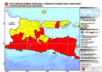
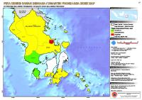
PETA INDEKS RAWAN BENCANA / DISASTER PRONE AREA INDEX MAP
DI PROVINSI BALI / IN BALI PROVINCE
Keterangan lokasi / Location diagram
8°0'0"S
LAUT BALI Legenda / Legend Batas Propinsi / Province Boundary
Batas Kabupaten / District Boundary
Tingkat Kerawanan/Prone Level
BULELENG
Rendah/Low
Sedang/Moderate Tinggi/High
BANGLI JEMBRANA
BALI
Informasi Kartografi / Cartographic Information
KARANG ASEM
TABANAN
4
8
16
24
Kilometers
Skala / Scale : 1 : 700.000 pada ukuran A3 / 1 : 700.000 at A3 size 1 cm di peta sama dengan 7 km dilapangan / 1 cm equals with 7 km in the field Proyeksi Lokal / Local Projection : UTM, Zone 50 South
GIANYAR
8°30'0"S
Å
0
Proyeksi Geografi / Geographic projection : Lintang - Bujur / Latitude - Longitude Datum Unit : WGS - 84
BADUNG
Unit Grid / Grid Unit : Lintang - Bujur dengan interval antar grid 0.5 derajat / Lat - Long with interval 0.5 degree
Sumber Data / Data Source
DENPASAR
JAWA TIM UR
Gambar background / Image background : Blue Marble
KLUNGKUNG
Batas administrasi/administrative boundary : Peta digital Bakosurtanal/ Bakosurtanal digital map Skala 1 : 250.000 / Scale 1 : 250.000 Indeks Rawan Bencana/Prone Area Index : Analisis Menggunakan DIBI (dibi.bnpb.go.id) 2002-2007/ Analisys Using DIBI (dibi.bnpb.go.id) 2002-2007,
Keterangan dokumen / Document properties ID peta / Map ID : 2010-12-9_rawan_bencana_BALI_BNPB Dibuat tanggal / production date : 09 Februari 2010/09 February 2010
SAMUDERA HINDIA 9°0'0"S
Dibuat oleh / produce by :
114°30'0"E
115°0'0"E
115°30'0"E